2002 eruption

Lava lakes reformed in the crater in eruptions in 1982–1983 and 1994. Another major eruption of the volcano began on January 17, 2002, after several months of increased seismic and fumarolic activity. A 13 km fissure opened in the south flank of the volcano, spreading in a few hours from 2800 m to 1550 m elevation and reaching the outskirts of the city of Goma, the provincial capital on the northern shore of Lake Kivu. Lava streamed from three spatter cones at the end of the fissure and flowed in a stream 200 to 1000 m wide and up to 2 m deep through Goma. Warnings had been given and 400,000 people were evacuated from the city across the Rwandan border into neighbouring Gisenyi during the eruption. Lava covered the northern end of the runway at Goma International Airport, leaving the southern two-thirds usable, and reached Lake Kivu.[4] This raised fears that the lava might cause gas-saturated waters deep in the lake to suddenly rise to the surface, releasing lethally large amounts of carbon dioxide and methane[5] – similar to the disaster at Lake Nyos in Cameroon in 1986. This did not happen, but volcanologists continue to monitor the area closely.
About 147 people died in the eruption from asphyxiation by carbon dioxide and buildings collapsing due to the lava and earthquakes.[4] At least 15% of Goma comprising 4,500 buildings were destroyed, leaving about 120,000 people homeless.
Immediately after the eruption stopped, a large number of earthquakes were felt around Goma and Gisenyi. This swarm activity continued for about three months and caused the collapse of more buildings.[4]
Six months after the start of the 2002 eruption, Nyiragongo volcano erupted again. Activity at Nyiragongo is ongoing, but currently confined to the crater, where another lava lake has formed about 250 metres below the level of the 1994 lava lake.
BBC news reports for images of the eruption and after effects.
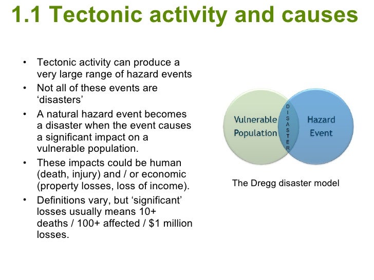
Apply Degg's model to this case study to determine the risk of disaster of Mount Nyiragongo.
Use the information in the CIA factbook to add to a venn diagram (vulnerability of the 1 million people of Goma people). Add facts about the nature of the volcanic eruption (hazard event). Read this article to add more information to the vulnerability or hazard side of the diagram.
Make a comparison - repeat the exercise for the E volcano eruption - details from your case study notes and the link on Cool Geography. CIA factbook information. But remember it was not just Iceland that were vulnerable to the eruption - there were global impacts, can you add this to the diagram?